
CamAlien
High-speed camera system for monitoring vegetation and objects along roads
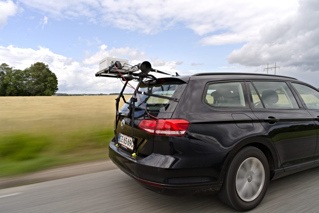
CamAlien is a high-speed camera system designed for efficient monitoring of vegetation and objects along roadways. The camera system captures high-quality images at rapid intervals, to monitor the full roadside when following traffic speed. The system utilizes a global shutter sensor for accurate scene rendering and geotagging for precise data collection. The camera system makes it possible to collect extensive data sets, which can be used for a digital library of road object types and locations, but also subsequent training of machine learning algorithms for automated object recognition.
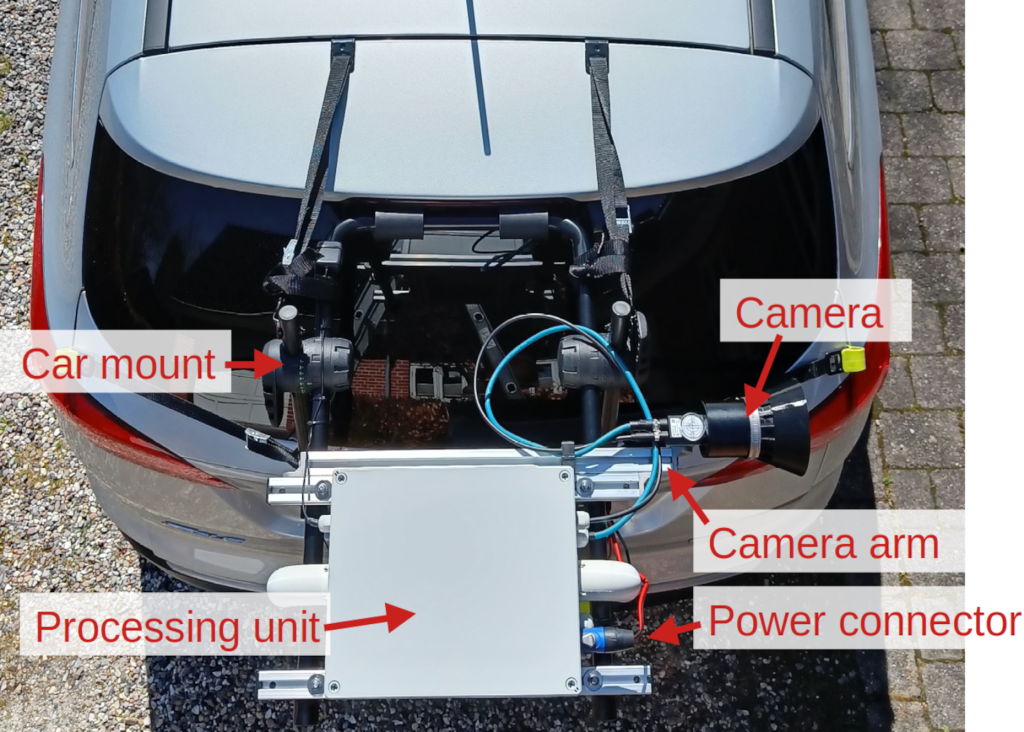
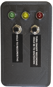
CamAlien consists of a camera mounted on an adjustable arm, a real-time GPU-accelerated processing unit, remote controller, and a car mount. Furthermore, it has two types of power connectors, allowing it to be powered either from a car with 12 VDC or from a socket with 100–240 VAC. The physical remote controller allows easy control and simple monitoring of the system.
130 km/h
Design speed
13
Countries in active use
Jetson AGX Orin
Real-time GPU edge unit
System overview
Web interface
Control, monitor,
configure.
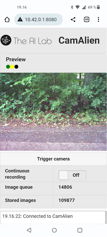
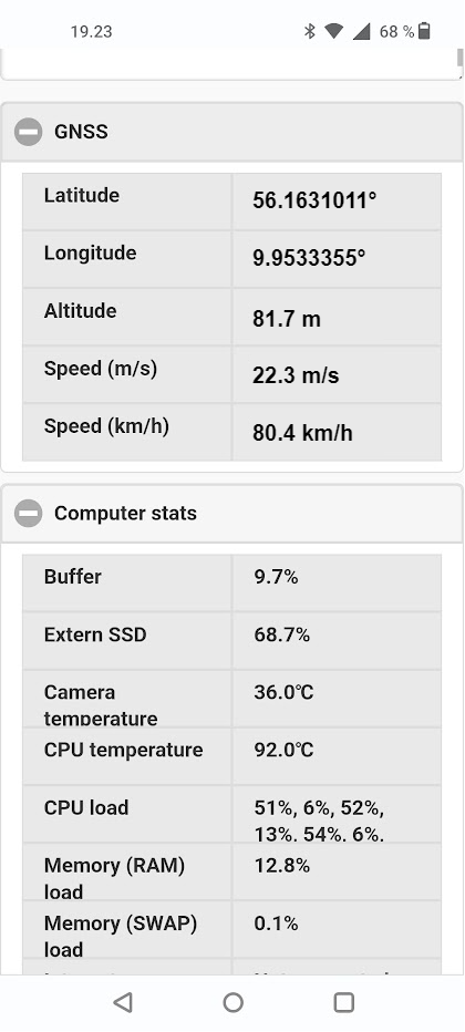
In addition to the physical remote controller, the system also has a web interface allowing control, monitoring and configuration of the system. The web interface includes:
- Live video stream
- Controls for starting and stopping recording
- Current number of images in buffer and external disk
- Status field with human-readable info messages
- Current GNSS data including position and speed
- Computer statistics including disk usage and temperatures
- Shutdown and reboot controls
Software
Buffered capture,
anonymised at
the edge.
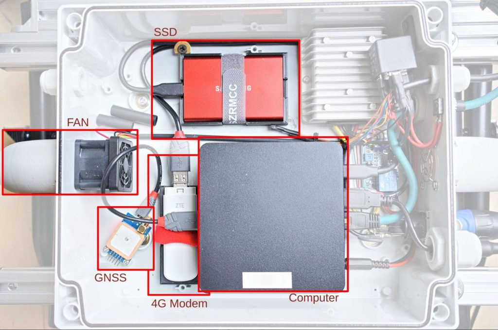
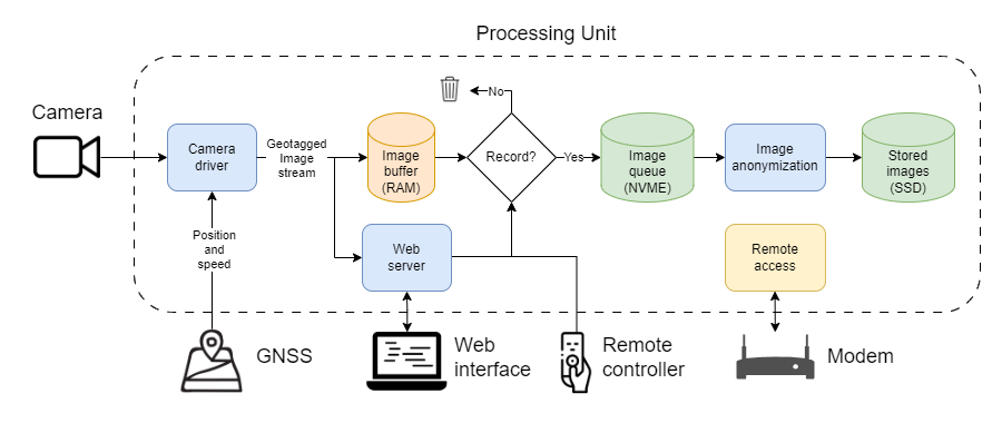
The processing unit of the system includes a real-time GPU-accelerated compute element that is connected to the camera, the GNSS module, the modem, and the remote controller. The figure below illustrates with a flowchart how different components of the system are connected, and how images flow from the camera, through the memory (RAM) and an internal queue, and are finally stored at an external SSD.
A buffer allows the user to record images for a configured number of seconds back in time, when a button is pressed in either the web interface or with the physical remote controller. When recording is active, raw images are stored on a fast internal NVME disk. From here, they are anonymized asynchronously using a pre-installed AI model that automatically detects and removes people, bikes, and cars from the images. As the system includes a real-time GPU-accelerated Nvidia Jetson AGX Orin compute unit, it is furthermore possible to replace the pre-installed AI model with custom models running in real-time. Finally, the anonymized images are stored to an external SSD.
Speed, quality and coverage
Short exposures,
adaptive frame rate.
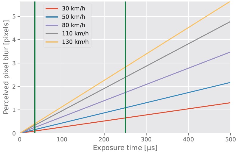
The camera system is designed for high speed, up to 130 km/h. To get high-quality images at these speeds, a global shutter camera is needed, and the exposure time needs to be short to ensure a low amount of pixel blur. The graph illustrates the relation between speed, exposure time and perceived pixel blur.
CamAlien automatically adjusts the exposure time based on the current speed to obtain the best possible image quality. Furthermore, the frame rate is adjusted accordingly, to obtain full coverage of the road side at a configurable distance. That is, the system is designed to maintain a small overlap between consecutive images.
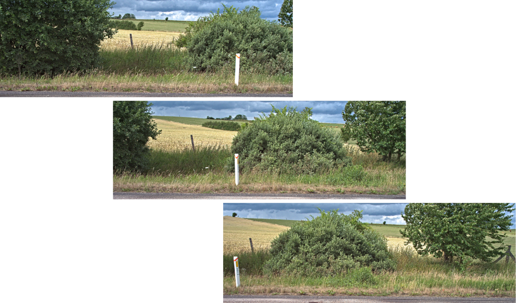
Sample images acquired while driving
Captions are the actual telemetry recorded with each frame.


Other use cases
Litter and
road kill.
CamAlien can also be used for detecting and mapping litter in the roadside. Learn more about automatic litter detection →


The following images show how CamAlien was used for detecting road-killed animals


Deployed systems
Our customers say
CamAlien was first developed in 2023 on request by the European biodiversity partnership Biodiversa+, where it is still today actively used in 11 countries as a car-mounted camera system to map invasive alien plant species along roads across Europe.
The Biodiversa+ pilot ‘Monitoring of invasive alien species with image-based methods’ (IAS) has released two reports covering their experiences with CamAlien in both 2023 and 2024.

“the data collection with the CamAlien system was smooth”
IAS, First year report
In 2024, the CamAlien system received a remote software updated, and some partners started experimenting using CamAlien in trains and along rivers and canals.
“By implementing the adaptive recording, we managed to drastically reduce the amount of redundant data collected. All partners expressed enthusiasm about this new feature, which also made data handling much easier than during the previous field season.”
IAS, Second year report
“In France, the CamAlien was deployed on SNCF trains, whereas in the Autonomous Province of Bolzano (Italy) on SAD trains … In France and Belgium, the partners also experimented with taking photos with the CamAlien along rivers and canals”
IAS, Second year report
In 2025, an upgraded version of CamAlien was released, focusing on running AI models in real-time on the camera edge-device.
“In the final stage of the pilot, we will explore options for moving the image recognition models onto the camera systems to further reduce the time delay from observation to actionable information”
IAS, Second year report
“[…] The approach is starting to bear fruit. One European project, called CamAlien, is tracking invasive species using high-resolution cameras with machine-learning processing power, affixed to cars, boats and trains. As they speed along, they rapidly photograph the sides of roads and tracks, analyse the images in situ and upload alerts about alien invasive plants to a Europe-wide online map.”
“The system shows how, just in the past few years, new technologies combined with AI have ‘gone from mostly demonstrating potential to actually beginning to deliver real implementations’, says Toke Thomas Høye, an ecologist at Aarhus University in Denmark, who co-developed CamAlien. Some 16 European countries are trying out the technology to assess the distribution of invasive alien species.”
Nature ↗
Press


Price
11,380 € + VAT
CamAlien + 1 year support
More information
For more information, or if you want to use CamAlien for roadside monitoring, please contact us at: